Subscribe to our newsletter
Sign up for the latest news & offers from SafeSite
Quick and competitive quotes. Nationwide coverage
Quick quotes. Nationwide coverage
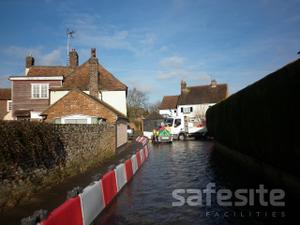
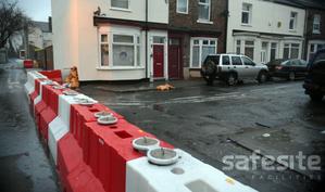
Are you at risk or currently suffering from flooding in your area? View our range of easy-install flood defence barriers
70 flood warning have been issued across England in recent weeks with large parts of the country submerged under water. Places hit the hardest include areas of Yorkshire, Derbyshire, Gloucestershire, Nottinghamshire, Lincolnshire, Warwickshire and Worcestershire. Around 22,000 properties have been protected by flood defences, including nearly 7,000 properties alone in Yorkshire.
Record rainfall recorded
Some areas have endured their “wettest ever autumns”, with the Met Office Tweeting that its Sheffield weather station had already recorded 427.6mm of rain (with 15 days still to go). The previous record was set in 2000 with 425.2mm of rain falling between September 1 and November 30 that year. Although river levels in some areas remain high, the Met Office has forecast drier weather in the coming weeks, and the Environment Agency says it is starting to think about moving from emergency rescue response into recovery.
However, as we have seen this year, and in previous years, the UK frequently sees deluges which deliver rapidly rising water levels in some areas, in very short timescales. Back in 2015 Storm Desmond saw a deluge of 34 cm of rain into the Cumbria area within a single 24 hour period – a rainfall record. And it’s been third time unlucky for Nottinghamshire’s flood-plagued towns.
These episodes of extreme wet weather can cause surface water flooding and localised drainage flooding, as well as presenting issues such as rivers bursting their banks, like the Severn and Avon in recent weeks, which have left properties waterlogged in Gloucestershire and Worcestershire. Residents in the Midlands and Yorkshire who have also been hit by heavy rain are still battling to clear their homes of floodwater and the debris it leaves behind.
But although some of these areas may be notorious for flooding, they are not the only vulnerable spots in the UK. In fact, according to the Environment Agency, approximately 5.9 million properties across Wales and England – that’s one in six homes – are at risk of flooding.
So where are these areas, and why are they at risk?
Coastal locations

Coastal erosion offers a specific risk to homes. Tidal flooding, particularly in a century that’s already seeing rising sea levels, can result in the gradual destruction of sea defences and the loss of permanent homes to the sea.
Areas of the UK particularly vulnerable to this type of flooding include:
Riverside locations
Many of the UK’s oldest, and even more recent settlements were built on riversides. Unfortunately, these locations are doubly at risk when the weather turns wet and the seasons stormy: tidal surges coming upriver from the sea, as well as rivers bursting their banks from significant rainfall over a short, sudden period of time.
Areas of the UK at particular risk include, but are by no means limited to:
Floodplain locations
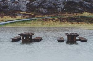
Whilst our floodplains are often beautiful, they are extremely vulnerable to flooding from heavy rainfall causing rivers to flow fast downstream and bursting banks. The prevalence of agriculture in floodplains has also had an effect on risk, through the removal of natural flood protection, such as hedgerows. Cumbria is an area known for considerable risk (Guardian).
Surface water
Surface water flooding is caused when flooding through downpours or other flood damage to drains (such as rivers bursting their banks and flooding drainage systems) affects drainage infrastructure. These events are often known as “flash flooding” and often affect urban areas, due to the high demand on drainage systems.
Areas frequently affected in this way include:
Wherever you live, it’s worth noting that despite ‘average’ rainfall year on year, the Environment Agency has issued a warning that flooding in the UK is likely to become more frequent, thanks to climate change.
How can you find out your level of risk?
Gov.uk holds a wealth of information and tools to help you plan ahead, help you during a flood and to recover after a flood. You can also view the latest river and sea levels near you and look up your property’s long term risk of flooding. Be prepared and sign up for advance flood warnings and view your area’s risk of flooding in the next five days.
Check the online Flood Map for Planning tool, to research any identified flooding risk to an area, based on a postcode search. This tool is linked to the Environment Agency research and data.
Search the interactive flood map provided by Friends of the Earth.
Look more closely at the flood risk to a particular property using the Gov.uk’s online service. This includes information on applying direct to the Environment Agency for data relating to a property, which can be extremely useful for insurance purposes and when deciding whether to purchase or rent a property.
Understand what the statistics or research information is telling you about your level of risk is also important. For example:
The Gov.uk postcode checker offers a clear indication of levels of risk according to zones:
Zone 1: low probability of river or sea flooding (less than 1 in 1,000 annually).
Zone 2: medium probability (between 1 in 10 and 1 in 1,000 annually for river flooding; between 1 in 200 and 1 in 1,000 annually for sea flooding).
Zone 3a: High probability – 1 in 100 or greater annual probability of river flooding; and 1 in 200 or greater annual probability of sea flooding).
Zone 3b: Functional Floodplain where strategic risk management and assessment is in place.
Results are offered in a visual map and text-based form, which immediately tells you the level of risk – dark blue areas of land are at risk of sea flooding) and makes it easy to tell if you are living (or proposing to live) in an area benefiting from flood defences.
The Environment Agency classifies areas with Medium and High risk of flooding, which means:
High risk: A more than one in 30 chance of the property being affected by flooding across one year.
Medium risk: a chance of between one in 30 and one in 100 that the property may be affected by flooding in a given year.
Once you know the level of risk to your wider area and immediate locality, it can be possible to minimise your overall risk by taking preventative action:
Hit by flooding? You might be eligible for financial help.
The Government has announced it will provide immediate relief on council tax and business rates to households and business owners significantly affected by recent flooding. Under the measures, households and businesses which have been intensely affected by the flooding will be eligible for 100% relief on their council tax and business rates for at least the next three months.
The Government’s Farming Recovery Fund will also be extended to support farmers badly affected by recent flooding across Yorkshire and the Midlands. Grants of between £500 to £25,000 will be available to help flood-hit farmers cover repair costs and get back on their feet.
In the first instance contact your local authority as it will be able to provide you with further guidance. Many councils have set up hardship schemes which are available to residents and businesses whose households or business premises have been affected by flooding.
If you think your property is at risk of flooding remain vigilant and take steps to prepare for flooding. Call us today for professional advice and to find out more about our range of flood defences.
We respond in under 30 mins on average (excl. weekends)
Sign up for the latest news & offers from SafeSite